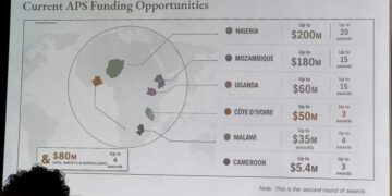







































































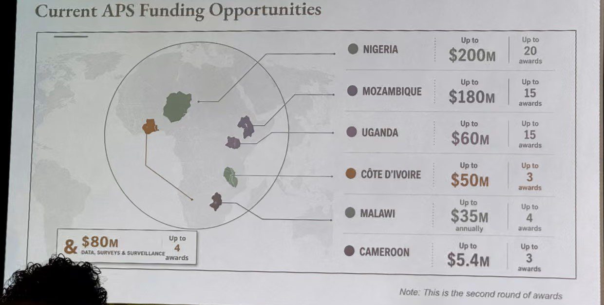
The United States government has apologized after an inaccurate map of Africa was displayed during an official presentation at an international health conference in Brazil, with every African country reportedly placed in the wrong location.
The incident occurred during the AIDS 2026 conference in Rio de Janeiro, where officials from the US State Department were presenting updates on America’s global health partnerships.
The error quickly drew attention from conference participants, many of whom photographed the slide and shared it across social media, sparking widespread criticism and disbelief.
Countries placed in the wrong locations
The map contained major geographical errors that affected every country on the African continent.
Among the mistakes, Nigeria was shown far away from its actual West African location and incorrectly placed within the Sahara region. Mozambique, located in Southern Africa along the Indian Ocean, appeared in East Africa, while Côte d’Ivoire was relocated from West Africa to an entirely different part of the continent.
Observers described the mistakes as unusually extensive for an official government presentation at a global event.
AI-generated image under scrutiny
Further examination of the presentation reportedly revealed that the map carried a digital watermark indicating it may have been created using artificial intelligence tools.
The discovery has fuelled renewed debate over the growing use of AI-generated content in official government documents and presentations, particularly when such materials are not thoroughly verified before public use.
US State Department accepts responsibility
Responding to the controversy, the US State Department admitted responsibility for the mistake and apologized to delegates, especially African representatives who attended the conference.
According to the department, the incorrect slide was introduced during last-minute changes to the presentation and was not properly reviewed before it was displayed.
Officials described the incident as an unfortunate oversight and stressed that it did not reflect the US government’s commitment to its partnerships with African countries.
Experts criticise lack of fact-checking
The incident has attracted criticism from policy analysts, health experts and academics, many of whom questioned how such significant geographical errors could pass through internal review processes.
Several commentators argued that the controversy highlights the dangers of relying on artificial intelligence without proper human verification, especially in diplomatic and international settings.
Others noted that basic geographical accuracy should remain a minimum standard for official government presentations.
Conference focus overshadowed
The presentation formed part of discussions on the United States’ international health programmes, including updates on the President’s Emergency Plan for AIDS Relief (PEPFAR), one of the world’s largest HIV/AIDS intervention initiatives.
However, attention quickly shifted from the health agenda to the inaccurate map after images circulated widely online.
Despite the controversy, US officials maintained that discussions with international partners during the conference remained productive and reaffirmed America’s commitment to supporting global efforts against HIV/AIDS.
The incident nevertheless serves as a reminder of the reputational risks governments and organizations face when using AI-generated materials without adequate quality control and independent verification.